Technical Services
MAPPING & GEOSPATIAL ANALYSIS
 Work smarter not harder! We save countless steps on our projects by having the best maps and data available on our field computers. We help other foresters, conservation biologists, land planners, and land managers with their GIS needs. Call us! We may have the perfect solution to save you time and money.
- Digital map packages
- Comparative sales data for appraisers
- GIS analysis
Unmanned Aerial Systems
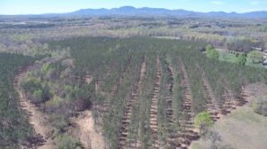 When the off the shelf aerial images don't not tell the story, we deploy drones to fill in the gaps and produce custom imagery and data to get the job done. Need to count tiny seedlings or know how may acres need to be replanted? No problem - we send out one of our licensed UAS Pilots. Our drones venture above foreboding thickets and briars to bring back information foresters need, without the blood, sweat, and tears of a person on the ground. We can count trees, measure heights, estimate acres, and even measure tree health.
- Extremely high resolution and outstanding quality aerial photography maps
- Aerial reconnaissance
- Industrial stock-pile volume measurements
- Log yard, mulch, and chip pile measurements
- 3D modeling
- LiDAR, multispectral, high resolution visible spectrum
- NDVI plant health analysis
3rd PARTY AUDITING AND FOREST INSPECTIONS
Details coming soon...
RESEARCH AND DATA COLLECTION
Details coming soon...
OTHER SERVICES INCLUDE:
- Endangered Species Consulting
- Forest Certification
- Wetlands Delineation
- Conservation Easements
